It's been a busy week here. Yesterday we packed up early in the morning and took a ferry from Valletta, Malta to Pachino, Sicily. From there we hopped a few buses and took a beautiful ride through the country, passing by the world's most active volcano (Mount Etna) along the way. We reached our hotel in Carini (in the province of Palermo, Sicily) in the afternoon and got situated for deployment. Billy will talk about that, so I will cover the other things that have been going on. Despite the nagging fatigue that we are all feeling, there have been some really great project improvements. Since these will also be addressed in similar blog posts, I will give a little update on mine: the archaeologist graphical interface.
I have already put together a majority of the framework for the interface, and recently began loading in cistern meshes. Due to the fact that Billy and Jeff have their code complete (aside from per-cistern fine tuning), the three of us can pump out a cistern model and have it online in about an hour. We will be doing this for each new cistern that we deploy the robot into. My project is still running into some choppiness which will be sorted out in 2-3 days.
Here is a sample of my progress as of today.
Note: If you are running Linux, you may run into difficulty with the Unity3D plugin.
I am still working on the textures/lighting of the cistern and water, the spherical linear interpolation of the rotational trackball (should be a quick fix!), and the photo selection on the right hand side of the interface. It may not be very easy to see, but right now all that the photo selection does is highlight a region on the wall that the selected picture shows. Once the photo selection is complete the model will rotate so that the highlighted area that the picture displays will be more visible and a frustrum with the robot's position and angle of view will be shown. I also intend to use Tim's higher quality go-pro pictures, rather than these stills from the video stream from last year. I might end up adding a big pop-up version of the photo as well. We'll see what happens. Aside from that, it's time to start rapidly uploading and spitting out cisterns as we deploy into them!
Showing posts with label robotics. Show all posts
Showing posts with label robotics. Show all posts
Monday, March 5, 2012
Saturday, January 7, 2012
Robotics in SLO Update
Over break, I sent the ROV we have here at Cal Poly to VideoRay for repairs. Several parts needed to be replaced due to water leaking into the robot's hull. To my knowledge it is still under repair.
As for the software side of robotics, I worked on SLAM. I was able to get the scan matching algorithm working. This algorithm attempts to use SLAM to converge every possible pair of sonar scans of a cistern in order to localize the ROV for each scan's position.
Before we added the "Auto-converge" localization technique, we were manually mosaicking the sonar scans together and then measuring the displacement values between a reference scan and all the other scans. The displacement values for each scan were inputted into the code and used as the initial locations of the ROV when trying to add scans to a map. The code we have now does this mosaicking automatically.
The next step is to figure out how to prevent the particles from converging in the wrong location. I'm writing a paper on the Malta work from last year up till now, which is consuming most of my time.
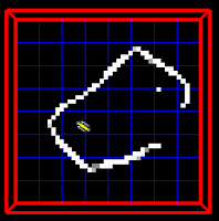
Here are before and after images of merging two scans. Here I'm just using SLAM to add the second scan.
As for the software side of robotics, I worked on SLAM. I was able to get the scan matching algorithm working. This algorithm attempts to use SLAM to converge every possible pair of sonar scans of a cistern in order to localize the ROV for each scan's position.
Before we added the "Auto-converge" localization technique, we were manually mosaicking the sonar scans together and then measuring the displacement values between a reference scan and all the other scans. The displacement values for each scan were inputted into the code and used as the initial locations of the ROV when trying to add scans to a map. The code we have now does this mosaicking automatically.
The next step is to figure out how to prevent the particles from converging in the wrong location. I'm writing a paper on the Malta work from last year up till now, which is consuming most of my time.
Here are before and after images of merging two scans. Here I'm just using SLAM to add the second scan.
 |  |

Monday, January 2, 2012
Winter Break Progress
Over winter break I had two tasks. The first task was to do some investigation into Google Earth's ability to display our findings. The second was to get everything prepared for our labs at Pacheco. The progress I made towards these two projects is summarized below:
Google Earth
I'm convinced that Google Earth will be a sufficient tool for sharing our results. It has every feature that we need: html formatting, easy to link to files from databases, image/video embedding, descriptions of each site, underground depth/maps. Additionally, it is commonly used software, making it easier to spread our findings.
That said, there are a few things that I haven't figured out yet. I don't know how to share a google earth file so that multiple people can edit it at once (aside from e-mailing the other person the file). I think the program has this capability, but I haven't figured out how it works yet. Another problem is that when you create a map of a place below ground (cisterns are below ground) the polygon won't show up on a map embedded into a website. The last problem is that I can get an embedded video to work on MY copy of google earth, but can't get an embedded video working in an embedded blog post like this one. Anyways, problems aside, here is a little sample that I made up.
If you have the Google Earth plugin installed, you should be able to view this. The camera should pan to my house and you will see some information about it when you click it. If you double click "Erik's house", it will zoom in to street view. Additionally, you may click the green polygon on the ground to see an outline of my underground lab, and again, some information on that. As far as I can tell, this is what we need for the project.
Pacheco Labs
I received a copy of the powerpoints and lecture notes from last year, and have been discussing everything with Chris, Jane, and the teacher from Pacheco (Jill). Looks like we're all going to meet up as a group on Wednesday at 12:10 to talk about the curriculum and maybe do a run through of the first demo that we will do for Jill's class on week 2. The first demo is a discussion of robotics, engineering, and then a demo of a line follower robot.
Over break I borrowed a Lego Minstorms kit from professor John Chen to make a line following robot. I got him working, but just barely. I was testing him out on brown cardboard with black electrical tape and poor lighting, and Jill's classroom is black/grey carpet so we will need to use masking tape. I will be going to her classroom on Wednesday afternoon to test out this one. The bots that we will be using for the week 4 & 5 demos will be borrowed from Jill, and the bots for the week 6 & 7 demos are in the LAIR, but need some repairing. I'll get to that in a week or two. That just about wraps everything up for now. More from me later!
Oh, and here are a few bad photos of the bot that I made for the first lab.


Thursday, December 29, 2011
Erik's Pre-Trip Learning Goals
Using what I know so far about ICEX, I have developed a few goals that I would like to have accomplished by the project's end. I'm sure that these learning goals will be revised as the quarter progresses, and I accept that there will be events that change my aim along the way that I have not yet considered. With that said, my pre-trip goals are the following:
I would like to gain enough knowledge of robotics and computer science principles to become a more well rounded systems engineer. In other words, I would like to be able to understand complex processes and systems that involve a variety of engineering disciplines. This is not a goal that can be perfected, but rather one that must be continuously worked towards. It will be difficult, and it does not end once ICEX is over (in fact, it never does)! I think it's safe to say that by partaking in the ICEX project, this is a goal that everyone on the team is working towards. I guess I'm in good company!
I was assigned two sub-projects to complete along the way. These projects are developing an interactive Google Earth (or other) copy of our findings for documentation and educational purposes, and keeping track of the curriculum that we will share with the kids at Pacheco Elementary and any other schools that we may be working with. My goal is to educate as many people as possible such that they will be interested in what robotics has to offer. Hopefully, if we do our job at Pacheco, a handful of the kids will use our labs as an incentive to work harder in school so that they can do the same things in their future. While the details of the Google Earth database are not as clear as of yet, I hope that the outcome of this sub-project will be just as beneficial.
Just like every other human, I have a knack for adventure. Malta will feed that knack! I'm ecstatic to be on another side of the planet learning about things that I have never encountered! When I'm on my deathbed and I ask myself if I lived a complete life, this is one of the things that I will use to convince myself that I did. Happiness is something that everybody strives for, and this is the best way that I can think of to be happy. My goal is to make the trip as fulfilling as it can possibly be; to jam it with adventure, to have a mind opening experience, and to bring back as many stories as I can cram into my brain.
Subscribe to:
Posts (Atom)